
February 27, 2025
By: Rebecca Anderson and Shannon McNeeley
Key Takeaways :
- The frequency and severity of catastrophic flooding events are rising throughout the US, and many rural communities are at high risk.
- Climate change is driving more intense and frequent extreme precipitation events, increasing the likelihood of catastrophic flooding across the US in the future.
- Rural communities face unique challenges in preparing for and recovering from catastrophic flooding, shaped by factors like geography, social vulnerabilities, and limited resources.
- Leveraging the extant strengths and assets of rural communities is essential for building resilience and effectively preparing for catastrophic flooding.
Catastrophic Flooding in Rural America
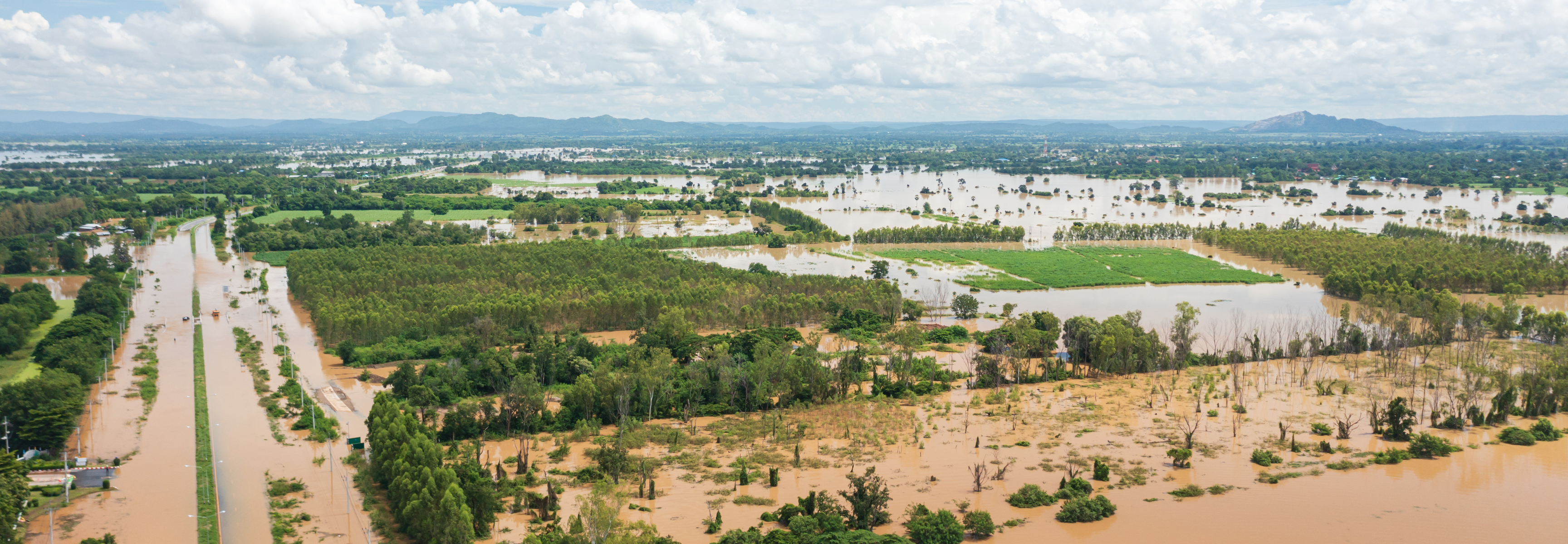
Extreme precipitation events are becoming more frequent and severe throughout the United States. This leads to more catastrophic flooding, generally defined as rare or exceptional high-magnitude floods that cause widespread destruction to property and/or loss of life. According to the US Billion-Dollar Weather and Climate Disasters database, the frequency of floods causing over $1 billion in damages has risen by 216%. In the 1980s, these events occurred at an average of 0.6 per year, but between 2015 and 2024, that number increased to 1.9 annually. These catastrophic floods happen in coastal and inland areas because of climatic changes such as extreme precipitation, rapid snowmelt, and/or sea level rise. This is combined with social factors like insufficient and aging infrastructure, building in floodplains, loss of wetlands, and developments with more impervious surfaces.
Catastrophic flooding events that result in large economic costs and losses of life and property pose a threat across the US. However, rural communities face heightened risks due to unique physical and social factors. Some rural areas are increasingly at risk of severe flooding because of higher poverty rates that correlate with living in flood-prone areas. Rural areas with few residents and/or population decline can mean limited capacity and resources for climate-resilient infrastructure projects, planning, and preparedness. Additionally, reliance on industries particularly susceptible to flooding, such as agriculture and mining, can put rural communities at heightened risk. For example, Central Appalachia is at high risk of catastrophic flooding because of a combination of factors including climate stressors, varied geography, demographic composition, and legacy of extractive industries. Additionally, many rural communities are situated in remote and hard-to-reach places. This can complicate efforts to implement flood-resilient infrastructure and disaster recovery. These challenges often lead to extensive damage to property, loss of life, and significant public health impacts following these events.
Catastrophic flooding can disrupt rural access to water and sanitation systems in numerous ways. This happens through power and water outages, erosion, landslides, mobilization of pollutants, contamination of water sources, and sewage overflows. Rural households that are not connected to community water and wastewater systems and instead rely on onsite septic systems and private wells face distinct risks. For example, private wells are particularly vulnerable to contamination after flooding. They are not regulated by federal drinking water standards, and resources to support well owners in addressing these risks are often limited.
Some examples of catastrophic rural flooding in the US include:
- Central Appalachia 1 in 1,000 rain event, July 2022: Central Appalachia, especially Eastern Kentucky, experienced extreme rain that led to catastrophic flash flooding in late July of 2022. NOAA categorized the rainfall as a 1-in-1000-year event, which means it has only a 0.1% chance of occurring in any given year based on historical data. Thousands of residents in Eastern Kentucky were displaced during the floods, with 45 reported deaths. The floods caused widespread damage to rural water and sewer systems, resulting in an estimated 18,000 service connections without water immediately after the floods, and another 45,600 service connections under a boil water advisory. The floods worsened already existing water affordability challenges in the region. Eastern Kentucky was hit with another catastrophic flooding event in mid-February of 2025. The event displaced hundreds of residents, left 14,000 customers without power, caused multiple wastewater systems to be inoperable, and took 23 lives (as of February 25, 2025). For some Eastern Kentucky residents, the disaster has triggered painful memories of the 2022 floods, reigniting trauma from past devastation.
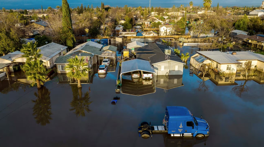
Pictured: Flood waters surround homes and vehicles in Planada, California in 2023. Source: The Guardian. Photo credit: Noah Berger/AP.
- Central Valley, California atmospheric river, January 2023: A powerful atmospheric river storm system hit the small farm community of Planada on January 9th, 2023. The heavy rainfall resulted in mandatory evacuations and damage to numerous buildings. The predominantly Latino town, with many low-income and undocumented residents, faced additional challenges in recovery due to ineligibility for some disaster relief.
- Upper Midwest extreme rainfall event, June 2024: A weather pattern stalled over the Upper Midwest in mid-June 2024, resulting in extreme rainfall and catastrophic flooding in Minnesota, South Dakota, Iowa, Wisconsin, and Michigan, killing four people and costing $1.1 billion in damages. In Southern Minnesota for example, several thunderstorms formed between June 19-21 producing 4-6 inches of rainfall and causing record flooding. The extreme flooding left rural and urban areas without power and safe drinking water and destroyed farms, negatively impacting rural livelihoods.
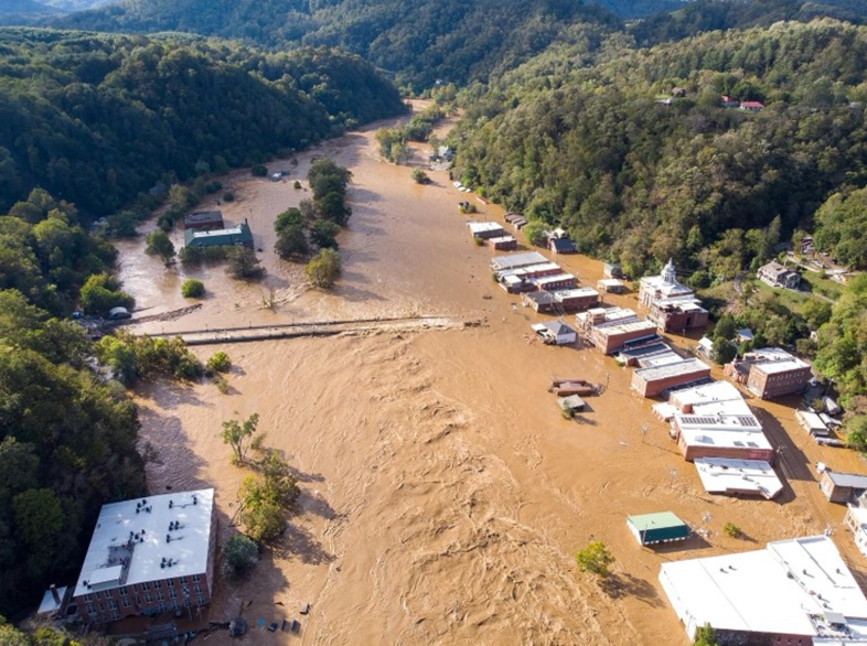
Pictured: Marshall, North Carolina, flooded the weekend after Helene in September 2024. Source: North Carolina State Climate Office Blog by Corey Davis. Photo credit: Old Marshall Jail Hotel.
- Southern Appalachia Hurricane Helene, September 2024: South Central Appalachia experienced heavy rainfall after Hurricane Helene made landfall in Florida as a Category 4 hurricane. Helene caused over 200 deaths, making it the third-deadliest hurricane in modern history, with half of the fatalities in North Carolina. Socially vulnerable populations such as the elderly and people with disabilities in North Carolina were most affected, with rural areas in the state experiencing significant impacts. For example, the rural area of Busick, North Carolina received 31.33 inches of rain over three days. The extreme precipitation resulted in catastrophic flooding and landslides, resulting in an estimated $59.6 billion in damages in North Carolina alone. Federal Emergency Management Agency flood maps underestimated the flood risk area, leaving many inundated properties without proper flood insurance.
The Growing Role of Climate Change in Catastrophic Flood Events
Without reductions in emissions of greenhouse gases (GHGs) such as carbon dioxide and methane, global temperatures will continue to increase. Scientists have warned about the global climate emergency, yet progress is slow and 2024 marked the hottest year on record. One of the results of a warming climate is heavier and more intense precipitation events due to warmer oceans and higher levels of moisture in the air. Human-caused warming is driving the increased frequency and severity of extreme precipitation events across approximately 70% of the US. More intense rainfall events are causing a rise in frequent and severe flooding across the US, a trend expected to worsen. Scientists estimate that climate change will drive a 26% increase in the average cost of US flood losses by 2050 from $32.1 billion to $40.6 billion, with Black populations facing the highest increase in risk, bearing a disproportionate burden.
More frequent and intense catastrophic flooding is already devastating rural water and sanitation systems across the US. Understanding the multiple and compounding physical and social drivers of these events is key to enhancing preparedness and resilience in rural areas. Next, we untangle the interacting variables and examine the role of climate change in rural catastrophic flooding, focusing on the 2022 Central Appalachia event. This provides important insights into future risks and informs efforts to create equitable, climate-resilient rural water and sanitation systems.
Central Appalachia Historic Rain Event and Catastrophic Flooding in July 2022
What Does Science Tell Us About What Happened?
Before the precipitation event began, much of Kentucky was experiencing abnormally dry conditions. On July 5th, 81% of the state was classified as abnormally dry, with 56% facing a D1 (moderate) drought. D1 drought can damage crops and pastures, cause some water shortages, lower stream, reservoir, and well levels, and lead to voluntary water-use restrictions. The conditions intensified rapidly – in just two weeks the area under a D1 drought surged from only 5% on June 21st to more than half the state by early July. Dry conditions can cause soil to become hard and compact, reducing its ability to absorb water and increasing the risk of runoff and flooding when rainfall occurs.
The challenge of dry, compacted soil was exacerbated by extensive surface coal mining (also known as mountaintop removal) in the region, which strips away vegetation and disrupts soil and rock structure to extract coal, further reducing permeability and making the land even less capable of absorbing rainfall. When scientists explored the impact of mountaintop removal on the 2022 Eastern Kentucky floods, they found it potentially contributed between 22-100% of stream discharge, depending on the location in the watershed. Furthermore, the region’s history of surface mining, coupled with the recent decline in coal mining operations, has contributed to persistent economic inequality and deteriorating infrastructure – factors that further heighten the region’s vulnerability to flooding.
According to the National Weather Service, light rain began in the region on July 25th, becoming heavier early on July 26th. Multiple training thunderstorms – a series of storms that repeatedly develop and pass over the same area – formed over Eastern Kentucky between July 26th and 29th, bringing rainfall totals exceeding 600% of the normal amount. In some areas, up to 14 to 16 inches of rain fell over 4 days, an event so rare that it has less than a 0.1% chance of occurring in any given year. Several factors contributed to this extreme and prolonged rainfall: (1) warm, southerly winds carried large amounts of moisture from the Gulf of Mexico, (2) a stationary front over southern Kentucky provided the necessary lift to trigger storms, and (3) an upper-level jet stream north of the front helped sustain multiple thunderstorms, causing prolonged heavy rain over the four-day period.
The combination of hardened soil from drought and mining with extreme rainfall led to devastating flash flooding in Central Appalachia, particularly in Eastern Kentucky. Between July 26th – 30th there were 24 Flash Flood Warnings issued, some of which escalated to Flash Flood Emergencies – an alert reserved for catastrophic flash flooding events. Multiple rivers in the area reached record flood stages. A gauge in Whitesburg, Kentucky, recorded the North Fork River cresting at 22 feet before the gauge failed. This significantly surpassed the previous flood record of 14.7 feet set in 1957. The catastrophic flooding caused significant damage and loss of life in Eastern Kentucky, especially in small, rural communities built along small creeks in narrow valleys known as “hollers” (hollows).
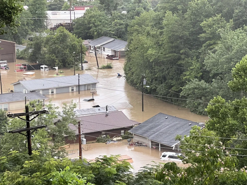
Pictured: Rescue teams use kayaks to search for residents in floodwaters in Whitesburg, Kentucky in July 2022. Source: Klesta, 2024; https://doi.org/10.26509/frbc-cd-20230927; CC BY-NC 4.0 License; no changes were made.
What Does Science Tell Us About What Will Happen in the Future?
Observed and projected shifts in precipitation and drought patterns help explain the catastrophic 2022 Central Appalachia floods and offer insight into future risks. Since the 1950s, extreme precipitation events have increased by 37% in the Southeastern US, with rainfall patterns shifting to bring more precipitation in the fall and drier conditions in the spring and summer. The Southeast is expected to experience more extreme precipitation events in the future due to higher levels of atmospheric warming, which can cause increased moisture in the air. Research suggests that while overall thunderstorm activity in the US may shift seasonally, storms are projected to become more frequent in the Southeast. Particularly, the most intense storms, capable of producing extreme rainfall, are projected to become more frequent in the summer, with moderate storms decreasing during this season across the Eastern US. Additionally, all categories of thunderstorms, including the most intense, are expected to increase in the fall, winter, and spring in the Eastern US. Extreme rainfall is also likely to increase in the Southeast due to tropical storms and hurricanes (e.g., the Southeast experienced extreme rainfall from Hurricane Helene in September 2024). By 2100, the number of tropical cyclones that bring record-breaking rainfall could increase by 7 to 36 times in the Southern US.
The seasonal changes in precipitation patterns and higher evapotranspiration rates make the Southeast region more drought-prone than other parts of the Eastern US. Flash droughts, defined by their sudden onset and rapid intensification (e.g., the swift emergence of D1 drought in Kentucky during June and July 2022), are becoming more frequent worldwide as rising temperatures and drier conditions accelerate their development. In the Central US, including Kentucky, flash droughts are most common in July and August, while in the Southeast, they peak in May. Research shows that flash droughts are drying out soil faster than in the past as the world warms.
The increasing frequency of extreme precipitation events and more frequent droughts in a warming climate can heighten the risk of flash flooding. Appalachia, a region historically prone to flash flooding, especially in the spring, is expected to experience more frequent and severe flood events. One study predicts the US will likely experience more flash flooding under higher future emissions. It found that a 100% increase in extreme rainfall is correlated to a 10% rise in flash flooding. In the Appalachian region, characterized by steep “hollers” (hollows) that are especially vulnerable to flooding, flash flood frequencies are expected to nearly double by the end of the century as the cause of flooding shifts from snowmelt to extreme rainfall events.
It was these compounding climate and geographic variables combined with social vulnerabilities that led to the catastrophic flooding impacts that resulted in major displacement and loss of lives and property in Central Appalachia in July 2022. Future climate and precipitation trends suggest that catastrophic flooding events like these will become more frequent and severe in the region, as evidenced by the February 2025 catastrophic flood event in Eastern Kentucky. This emphasizes the critical need for rural communities to have the necessary resources and infrastructure to prepare for, withstand, and recover from these devastating events, which are driven by both climate change and social factors. Similar challenges exist across the country in rural areas, where the intersection of climate change and social inequities is intensifying flood risk in different ways.
Rural Communities: Opportunities in Building Resilience
Rural communities face unique challenges in responding to catastrophic flooding, yet their strong kinship ties and mutual aid play a crucial role in recovery. While community solidarity is not exclusive to rural areas, tight-knit relationships and shared history are central to how rural communities come together to support each other in times of crisis. For example, after the 2022 Eastern Kentucky floods community members set up an impromptu mutual aid center in Knott County to share resources and supplies. Water utilities from across the region also helped rural water and wastewater systems in Eastern Kentucky return to delivering safe drinking water and sanitation services. Crews from over 20 Kentucky water utilities, and even some from Virginia and West Virginia, provided personnel, equipment, and materials. These responses reflect the deep social capital built from generations of resilience in the face of repeated flooding and economic hardship in Central Appalachia. The importance of reciprocity as a value may be shown by 2022 Eastern Kentucky flood survivors quickly helping Hurricane Helene victims in October 2024, and the North Carolinians then swiftly offering aid back to Eastern Kentuckians in the February 2025 flooding event.
Rural communities are also adopting innovative strategies to increase resilience to catastrophic flooding. Some communities in Kentucky are repurposing abandoned mountaintop removal mining sites to develop housing and neighborhoods at higher elevations. By relocating to these areas, residents are proactively reducing their risk and seeking greater protection from future catastrophic flooding events. However, high rates of absentee land ownership or large areas held by land-holding corporations may decrease the availability of housing on higher ground.
The Pacific Institute and Livelihoods Knowledge Exchange Network (LiKEN) partnered with communities and rural technical assistance providers to form the Water and Climate Equity Project. The project aims to co-identify and co-design strategies and approaches for climate-resilient water systems with residents and leaders in rural communities. We also aim to contribute to community capacity building for climate and water resilience in rural areas across the US and catalyze the production of actionable knowledge on adaptation and emergency disaster preparedness. Among the contributions of this project are various reports of our findings and toolkits for communities and water systems to increase transparency and share knowledge. We published an assessment of the climate risks and resilience of rural water systems across the contiguous US with a focus on the Central Appalachia and Southwest regions. The project team developed a toolkit for assessing climate change, water, and environmental justice to support frontline communities and water utilities. The partners also co-developed the Harlan County Water Resilience Toolkit, which is being tested for its utility in light of the February 2025 catastrophic flooding event. The Water and Climate Equity Project becomes more relevant with each extreme weather event.