
California Coastal Areas and Infrastructure Vulnerable to Flooding and Erosion
California Coastal Areas and Infrastructure Vulnerable to Flooding and Erosion
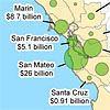
Downloadable PDF maps from our study that allow you to visualize the impacts of sea level rise on the California Coast. Key impacts featured here include population and property at risk, miles of vulnerable roads and railroads, vulnerable power plants and wastewater treatment plants, and wetland migration potential. This information is being made available for informational purposes only. Users of this information agree by their use to hold blameless the State of California, and its respective officers, employees, agents, contractors, and subcontractors for any liability associated with its use in any form. This work shall not be used to assess actual coastal hazards, insurance requirements, or property values and specifically shall not be used in lieu of Flood Insurance Studies and Flood Insurance Rate Maps issued by the Federal Emergency Management Agency (FEMA).
Overview
Resources
In this Series